Showing posts with label Motorbike. Show all posts

Saturday, 15 April 2023

Into the Clouds

Two taxis and over a thousand dollars later, I find myself on the outskirts of Hà Nội looking at a pre-loved Honda XR 400 which I am hoping will carry me through the mountains northwest of the city.

After filling up with petrol, I remind myself how to ride a motorbike on the hectic streets of northern Hà Nội. Surviving, just, I scale the entrance ramp to the motorway and the lesson steps up a gear. It is the quickest way out of the urban jungle.

Soon I am heading into the mountains towards Hòa Bình and Mai Châu, joining National Route 6 and climbing Thung Khe Pass. The road has been carved into steep-sided limestone karst mountains, but low-hanging clouds obscure the views. Applying the old adage, the descent proves to be more challenging and nerve-wracking than the ascent. The smell and sound of hardworking brakes shroud the mountainside in a similar way to the low-hanging clouds.

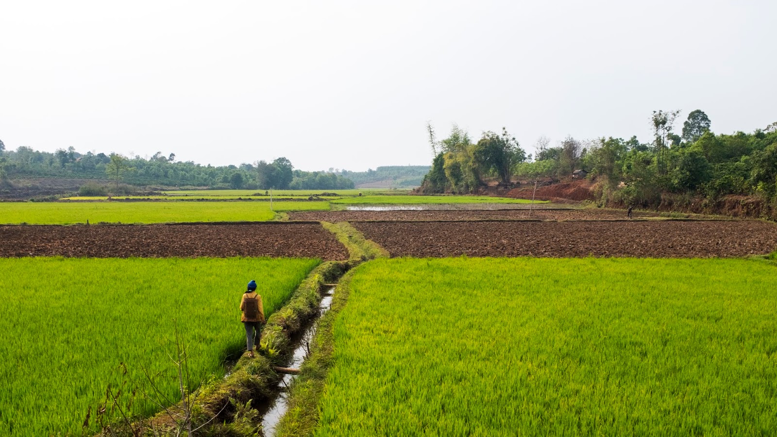
Beyond Mai Châu the roads become the type I came here to ride: light on trucks and heavy on wiggles. I cross the river at Bến Phà on a little ferry, stop for a random roadside phở and follow the Sông Tấc River through a patchwork of paddy fields towards Bắc Yên.

From here I follow the Cloud Hunters into the Tà Xùa Nature Reserve. Eventually I pop out of the clouds and see what all the Instagrammers have come for. Honestly, it is spectacular. What catches my attention more is that in places they are still building the road. I tentatively follow the locals through the construction site, balanced on the edge of a huge precipice.

It is at some point on the climb that I notice both my speedometer and odometer have stopped working. Since the bike has no fuel gauge, I now have no way of knowing how much fuel I have in the tank.

The problem becomes more pressing the next morning when the engine refuses to start. Mr Huy takes one look and essentially tells me to push it. He and I push the 125 kg bike up the hill before I freewheel down the other side to the town mechanic. At 10:22 the engine first splutters back into life. By 11:13 I am ready to go.

Well, except the speedometer and odometer are still not working.

For the next few days I weave through farming villages and lush mountainous terrain, crossing from valley to valley between Yên Bái Province, Sơn La Province and Lai Châu Province. I buy petrol in 500 ml plastic bottles from roadside shops and fill my head with numbers as I try to guesstimate how far I can go before needing to fill up.

The final reward is Sa Pa, perched dramatically at around 1600 metres on the western edge of a high plateau, facing the hazy blue peak of Mount Fansipan, Vietnam's highest mountain, across the Mường Hoa Valley. The motorbike finally goes back to the garage to fix the odometer, giving me a few hours to think about how great the ride has been.

After a day off hiking in the Sa Pa countryside, I set off for Hà Nội. My little navigation system gets confused by the steep-sided valleys and, like an idiot, I follow it mindlessly up into a village perched high on the mountainside. I retrace my tyre tracks down a 17% gradient and eventually find the right road.

Then I see the first sign to Hà Nội.

I get giddy, but as I turn onto the motorway a woman jumps in front of me and shrieks. A few moments later a guy bumbles over and explains in broken English that motorbikes are now prohibited.

I take a few moments to replan my route.

The news is not good. There was only one thing for it...

Eventually, on my way back to Hà Nội, I began to question my actions.

Little did I know, karma had already passed judgement and Mother Nature was about to deliver the sentence.

Monday, 2 April 2018

Pass Cloud Ocean

Over breakfast, it dawns on me that I am about two thirds of the way towards Hanoi and I am about two thirds of the way through my time in Vietnam. This means that I can make it to Hanoi, but I will have no time to explore the captivating capital. Neither will I be able to explore the thousands of amazing limestone islands of Halong Bay. By the time I have devoured my breakfast noodles, a new plan is in place...

Built on a hill overlooking the Perfume River, 4km southwest of the Citadel, Thien Mu Pagoda is an icon of Vietnam. The scenic ride, along the river, to the 21m-high octagonal tower, the first stop on my journey south back towards Da Nang.

To get to Da Nang, I have to traverse a spur of the Truong Son mountain range that juts into the sea, so I choose to, once again, ride switchback after switchback up and over the jaw-dropping Hai Van Pass - yes, it really was that good!

Upon arriving, my first job is to sell Harry back to a friend of his previous owners. I love this motorbike! With no time to get sentimental tho, I change my clothes, donate some of my old sweaty motorbike gear to the owner of the garage, repack and head to the train station.

The state-run Vietnam Railways are ageing, but offer a relaxing way to get to the capital city. I choose the most comfortable option (apart from the luxury carriages), a top bunk bed in the 4-berth soft-sleeper compartments. Since I paid the 30p extra to sleep in the VIP section, my carriage is air-conditioned and the sleeping berths are soft and comfy. There are perfectly adequate toilets and wash basins in every carriage, and the general standard of cleanliness is pretty good. A nice touch from Vietnam Railways is a desk lamp in each compartment, filling the space with soft, ambient light. Sadly, the other endearing little traditions that I read so much about have disappeared; instead, I am presented with a miniature bottle of water.

Shortly after boarding, the night train jerks into life! The clickity-clack of the rails is part of the romance of any train journey, but this is another level. After rolling out of Da Nang Station, the train rattles through the night towards Hanoi.

With the motorbike part of the adventure over, it is time to relax and reflect on my time in Vietnam. Astonishingly exotic and utterly compelling, Vietnam is a country of breathtaking natural beauty. I am truly amazed by the spirit, determination and sheer lust for life of the Vietnamese people. I will return someday soon to finish my journey.

Distance: 139.6km

Sunday, 1 April 2018

Đèo Hải Vân - Ocean Cloud Pass

A contender for the most famous road in Vietnam, the Hai Van Pass is a short but scenic route winding around a mountainside above the East Sea, on the central coast. The Ocean Cloud Pass is famous for a number of reasons, but I heard of the Hai Van Pass through the Top Gear Vietnam Special, in which the presenters waxed lyrical about the pass, inspiring myself and a generation of travellers to take to the road on two wheels and hit the Hai Van Pass.

To avoid the worst of the traffic, I leave Hoi An’s old town early and take the coast road to Da Nang. On the edge of the city centre, I turn west onto the famous Dragon Bridge over the Han River and into the city. I then cruise along the river bank before skirting the ocean along Nam O Beach. At the end of the beach road, I join Highway 1 for a short stint before the road starts to climb into foliage: this is the start of the Hai Van Pass.

Curling around the mountainside, the pass opens up spectacular views across Da Nang Bay. At the top of the pass, a collection of overpriced food and drink shacks vie for my custom, as I stop briefly to consider whether to scramble to the ancient gate and old gun towers. The Top Gear Vietnam Special must surely have inspired thousands of travellers to follow in their tyre-tracks, because one of the hawkers at the top of the pass asks me: “Are you here because of Top Gear?!” With this question, my decision is made. I clunk my bike into gear and ride off just as a huge bus full of tourists pulls up.

Snaking down the other side of the pass, the views get even better: looking over the winding tarmac as it drops towards the long, empty beach of Lang Co. Just after one of the last hairpin bends of the pass, a picture-perfect scene opens up over Lang Co bay and fishing village, with a long bridge over the water and the lush, misty mountains behind. This might as well be known as the ‘Top Gear Viewing Point‘, as it was here that the final scene on the Hai Van Pass from the Vietnam Special episode was filmed, with the three co-presenters all gazing at the sunset, enraptured by the beauty of Vietnam’s landscape.

Although it is certainly not the greatest road I have ridden in Vietnam, the Hai Van Pass is still a lot of fun to ride, with excellent views and hardly any traffic.

Sadly, after the fun of the Hai Van Pass, it is necessary to join Highway 1 briefly. The turning for the Chan May coast road cannot come soon enough. The Chan May road is empty and stays close to the coast. Veering left off the Chan May route, I head towards the short and sweet Phuoc Tuong Pass - a mini Hai Van Pass. On the other side of this pass, I weave my way across Highway 1 to join a dirt road (QL49B) which heads north along the shores of the Cau Hai Lagoon, one of southeast Asia’s largest lagoons.

Just outside the ancient capital of Hue, at the end of the sweltering sandbar that forms the east coast of the lagoon, I see an opulent phoenix soar through the heat while a diligent caretaker gently rinses sand from its mosaic talons. I slow down and see acre upon acre of screaming dragons skirmish for superiority as gilded crosses and Buddhist swastikas tower into the afternoon sky. This is Vietnam’s City of Gods.

I have mixed feelings about Vietnam’s extravagant tradition, especially when a lot of the country is living in homes much smaller than these palaces for the dead. I mull this over as I ride to the end of the peninsula and follow the Pho Loi River into Hue.

After a pitstop to freshen myself up, I jump in a taxi to race to the heart of Hue, the Citadel. At this time of day, most of the tourists have gone home. I am therefore able to enjoy a leisurely stroll around the bizarre combination of meticulously restored palaces and weed covered ruins, as the sun dips below the crumbling century-old walls.

Distance: 189.7km

Saturday, 31 March 2018

Into the Mountains...

The first hour of riding is along a dead straight ribbon of asphalt that bisects the Kon Tum Plateau, which is covered in plantations of towering rubber trees and coffee bushes. Silhouettes of mountains loom on the horizon and there is a fruity, flowery smell in the air as it gets cooler and thinner.

Dak To is a forgettable town with a notable history. The surrounding area was the scene of some of the fiercest battles of the American War. The countryside still bears the scars of all the bombs and defoliants that were dropped. A few kilometres after passing Dak To, there is an old US landing strip just to the south of the road. The long stretch of tarmac is still visible through the fields of crops that have grown up around it. I leave the road to ride along the landing strip and notice farmers using it to dry their crops on.

The Ho Chi Minh Road soon follows the valley of the Dak Po Ko River, not far from the Laos border. The mountains start to close in on the road. It looks as though the trees have been vacuumed off the hillsides as the cultivation continues right to the top. This gives a somewhat patchy appearance to the landscape in this area and is a reminder that Vietnam is still a mostly agricultural economy.

The rivers become clearer and mountains higher; the air damper. Many houses are made of packed mud and straw, with wood panel walls and tiled roofs. Several impressive Rong Houses dot the countryside. Kids are everywhere: playing in the dusty front yards and waving at anything that passes.

Deforestation reaches its peak at the beginning of the pass out of Dak Glei: the scarred mountainsides are naked, save from some lonely trees that have escaped the chop. The landscape looks like the skin of a recently plucked chicken: a few tufts and clumps of feathers left on its pink, raw and exposed flesh.

Thankfully, things change at the top of the pass: agriculture is pushed from the mountainsides down to the river valleys, forced there by dense tropical forests that appear to melt over the mountains like candle-wax, dripping down the steep contours and washed by relentless cascades of rain-water, draining off the mountains in gushing waterfalls, and swelling the rivers below. It is a glorious ride all the way to Kham Duc, as the Ho Chi Minh Road twists up into the mountains, cutting a path through rock and along thickly forested river valleys.

Continuing north from Kham Duc to Thanh My, the Ho Chi Minh Road follows the Dak Mi River. This quiet stretch of road straddles the valley walls, sometimes high above the river, as it makes its slow but steady progress over the boulder-strewn riverbed.

At Thanh My, I say my final farewell to the Ho Chi Minh Road and head east along Road 14B through a maze of paddy fields to explore the hustle and bustle of Hoi An.

Distance: 297.3km

Friday, 30 March 2018

Ho Chi Minh Road

As I sit on my idling motorbike, waiting for the traffic lights to change, there is a subtle sign that I am no longer in the city. The laid back folks here are waiting for the countdown to reach zero before accelerating away.

The Ho Chi Minh Road runs along the mountainous spine of Vietnam. For much of its length, the road is a quiet, well-made, easily accessible, two-lane highway which sees very little traffic compared to the other major north-south road, Highway 1.

After negotiating through a glut of vehicles leaving Buon Ma Thuot, the Ho Chi Minh Road cuts northeast, as straight as a landing strip, over an agricultural plateau. The red soil – somehow deeper and earthier than previously – is a dusty plague of airborne particles, making the air thick and hazy, especially with the addition of the exhaust fumes from passing trucks. The red earth even appears to have changed the pigment of local people’s skin: much of the population on this plateau are ethnic minorities whose skin tone is darker and more leathery in appearance than lowland Vietnamese, as they spend much of their lives working outside on the land.

The Ho Chi Minh Road is in excellent condition all the way from Buon Ma Thuot to Pleiku. This is a good thing, because it makes an otherwise uninspiring leg of the journey more enjoyable.

Pleiku emerges from the dusty highland plains, looking as if a bag of concrete has been dumped over a hillside and left to dry. As Kon Tum is only another hours’ ride north of here, there’s not much incentive to stay in Pleiku. On the way out of Pleiku, I venture down some of the backstreets to discover the rough and ready character of Pleiku. Biên Hô Xahn has buckets of character. It is a great location with a view across a small lake: shady and quiet, a great place to enjoy excellent food and drinks.

Between Pleiku and Kon Tum, the Ho Chi Minh Road is arrow-straight and the scenery changes for the better. Rugged mountains grow up from the plains, where rivers provide enough water for rice cultivation. Since I am making good time I decide to leave the highway to explore the Minority Villages of the rugged Central Highlands, a cluster of several Bahnar villages on the periphery of Kon Tum. The Jarai villages still practise traditional customs, such as the feeding of the dead in traditional cemeteries, as do the 'Hilltop' Bahnar. As I look for these graveyards in the first few villages, a huge storm rolls in so I skirt the remaining tribal villages and open up the throttle to find shelter from the storm.

Kon Tum has a fabulous position: on the banks of the Dak Bla River with mountains behind. Peaceful during the day and pleasantly abuzz in the evenings, Kon Tum is a very characterful highland town: colonial buildings, riverside promenades and views of the surrounding countryside are just some of its merits. Near a suspension bridge across the river, near the large, immaculate rong is the village of Kon Klor. In this little green oasis is the Konklor Hotel where I can shelter from the storm and enjoy some delicious food.

Distance: 271.6km

Thursday, 29 March 2018

Blasting along to Buôn Ma Thuột

After a huge breakfast at One More Cafe, I ride through the streets of suburban Dalat which are lined  neatly with pine trees. The smooth tarmac of suburbia transitions to rough farming tracks and then off-road along what would in England be a footpath! The end of this section pops me out on the twists and turns of Highway QL27.

This is a welcome contrast to my previous experience of riding on a highway. There is very little traffic on this superb section of road. Mountain passes twist skyward, each hairpin bend revealing giant views over wide valleys, deep ravines, and mist-shrouded mountains. At times the jungle is so dense and lush that it appears to be uncontainable and threatens to grow over the road completely. A hypnotic rhythm is induced by the constant switch-backs – lean left, lean right – and the flashes of sunlight that pierce the thick foliage and streak the road at regular intervals. It is an exhilarating, but also strangely soothing, ride.

For the first time on this journey, I am reluctant to leave the highway, but leave it I do to take the backroad DT722. As I ride along the tarmac slowly turns to sand as I head further into the forest. I roll through tiny village after tiny village until I meet a river and, with it, some new friends.

Thoroughly confused by the lack of a bridge, as according to the maps - both paper and google - I should be able to cross here, I park Harry to explore the edge of the river on foot. I slip and slide down a steep sandy banking towards the river and see a tiny tin boat tucked into the bank. I try to communicate my request, with my three words of vietnamese and lots of pointing, to the owner of the boat. The tiny lady in the tiny tin boat seems confident that she can take Harry across the river. Given my linguistic limitations, I was unable to convey the size and weight of Harry (he's a bit of a porker). I scramble up the sand to return to my motorbike to figure out a plan B.

As my eyes reach ground level, I spy a crowd of curious children huddling around Harry. Despite the language barrier, we are able to understand each other and have a giggle together, essentially revving the motorbike as loud as possible and honking the horn.

After my new friends return to their games in the river, I retrace my tyre tracks to the main junction and continue across country, parallel to the river I was unable to cross. I nip across the highway once more to join a backroad which heads around a lake and cuts through a bedraggled landscape: a patchwork of small-hold farms and plantations; a previously forested region that has now been scalped. This throws me out onto the hellish highway (AH17) which I just blast along to get off this bloody road.

Buon Ma Thuot, the coffee capital of Vietnam, is not a particularly nice place, but nor is it anywhere near as bad as many guidebooks suggest. It is big, hot and busy. The streets around the old quarter, near the market, are full of lively commerce, interesting street food, local banter, and throbbing cafes. That said, I retire to my room early to try to solve a Type 7 Bristol Stool Scale problem from a pretty porcelain throne.

Distance: 246.1km

Wednesday, 28 March 2018

Back way to Đà Lạt

After a brief tour of the Ta Lai village, I choose the longest, but most scenic and rewarding route to Dalat by following the back roads. In excellent condition, the road 600A follows the Dong Nai River through a mixture of lush farmland and tropical rainforest until it meets the intersection of the DT725 and QL20.

After facing up to the bully boys on the highway yesterday, today I choose to avoid them further and follow the DT725. As I head further north on this road, the scenery gets greener, lusher and brighter. Rice paddies glow in the sunshine, lakes shimmer in the heat, eucalyptus trees line earthen dykes that divide the fields, and forested hills begin to appear on the horizon: the highlands are getting closer.

The road begins to head in a more easterly direction and, with the hills to the north and wide-open spaces to the south, it is a pleasant ride across to meet Highway QL27 and eventually rejoins the QL20.

With my wheels hitting the smooth tarmac of the highway, I am able to fly along the surprisingly empty roads. My confusion slowly subsides as I see a toll booth in the distance. I stop to check the map and discover that I have accidentally joined the CT14, a toll road parallel to the QL20. I search my pockets for enough money to pay the toll and I notice, out of the corner of my eye, a scooter peels off the main carriage way to what looks like a slip road. I watch, to my amazement, the scooter skirt the toll booths and rejoin the road to Dalat. Despite being unclear about the legality of this move, I stomp Harry into gear and mimic the manoeuvre to continue my journey.

I enter the outskirts of Dalat, the gateway to the southwest highlands. Grand gallic villas are dotted amid pine groves and the whole town is centred on a pretty lake. Before heading to my hotel, I stop to gaze at the wonderfully art-deco Crémaillère Railway Station. 

As I wander the streets of Dalat, the cooler air is a welcome relief to the stickiness of Ho Chi Minh. Tourist time ends at the joyously designed and outrageously creative Hang Nga Crazy House. This architectural exploration of surrealism is a B&B (which was sadly fully booked when I first arrived) and tourist attraction. I explore the maze of precarious tunnels, high walkways and steep ladders until darkness descends.

Distance: 256.5km

Tuesday, 27 March 2018

HCMC to Ta Lai Longhouse

From the moment I landed, I was drawn into Ho Chi Minh City's thrilling vortex and hypnotised by the perpetual whir of its orbiting motorbikes. I am amazed by the number of people on bikes and the number of people the Vietnamese fit on one bike! The past two days of exploring this wonderful city have rewarded me with a wealth of history, delicious food and a fine selection of excellent craft beer.

Each day of touring began with a huge slurp of a steaming pho, followed by exploring Ho Chi Minh City on foot and collecting many unforgettable moments along the way. The War Remnants Museum conveyed the brutality of war and highlighted the impact on its civilian victims. It is tough, but important to be shown the victims' version of the many atrocities committed by the US military action. Pho Binh is a humble noodle-soup restaurant with an important history. This was the secret HQ of the Viet Cong in Saigon. Next up, I entered a cloud of incense within the mystical world of the Jade Emperor Pagoda.

At the end of day two, I caught a taxi across the city to pick up a Honda CRF 250cc - Harry - my trusty stead for the long journey northwards. My first journey did not go so well. As I drove back to my accommodation, my brain struggled to cope with the volume of traffic and the bizarre traffic signals. As a result, I accidentally ran two red lights and unintentionally went the wrong way up a one way road.

Now, on the Centec Tower's 23rd floor, I am sitting on Shri's stylish terrace gazing over the neon city at night. Below the frenetic pace of life on the streets seems a World away, but tomorrow I shall be immersed in the dizzying, high-octane roads once more...

The tunnel network of Cu Chi became legendary for its role facilitating the Viet Cong rebellion during the American War. It symbolises the tenacious and ingenious spirit of the Vietnamese people in overcoming incredible odds. To get here, I meet Linh, my guide for the tunnels, and the pace setter for my introductory journey to Vietnamese rush hour traffic.

Getting to the Cu Chi Tunnels from downtown Ho Chi Minh City requires a brief but nasty stretch on Highway 13, leading north over the clogged Binh Trieu Bridge and out into the smog of Ho Chi Minh City’s industrial belt. But, just as the appalling industrial apocalypse becomes too much to bear, new roads cut north, towards Binh Duong New City. An eerie but pleasing spectacle, these smooth boulevards run through the centre of a new urban development that’s been laid out and constructed but has yet to be filled with people. It’s a pleasant and smooth ride through this ghost city and out the other side into the cold, damp rubber plantations.

After a brief, but refreshing, break at the rubber plantations, Linh and I push on to Ben Duoc. Rougher and unaltered for tourists, here is a more realistic exhibit of the Cu Chi tunnel system. Linh shows me how the ingenious people of Cu Chi survived in the harshest of environments and conquered their enemies against unbelievable odds. At the end of this truly awe inspiring experience, I say goodbye to Linh and head to Cat Tien National Park.

Out on the country roads, size really matters. The huge wagons and buses use their bulk and their horn to simply barge any traffic out of their way. The bully boys of the road make the journey draining, but as the light from Harry becomes stronger than the sunlight, I reach the ferry to cross the Dong Nai River.

Lying conveniently midway between Ho Chi Minh City and Dalat, Cat Tien National Park is an amazing area of lowland tropical rainforest. Within its boundaries is the indigenous village of Ta Lai, my home for the night. In the traditional-style lodge of Ta Lai Longhouse, I swap the buzz of motorbikes for the cacophony of cicadas, a warm meal and a bed.

Distance: 282.9km

Sunday, 18 August 2013

Beauty was where I hung my hat...

I have covered well over 6000 miles and that is it. Done.

I honestly did not know what to expect from this trip. My only hope was to find beautiful experiences that made my heart sing. The real revelation of this journey has been this land, this amazing place, populated with people who's character every bit the equal of this stunning landscape.

It has been long. It has been hard. Most of all it has been fun. I have laughed a lot. Like all journeys, the things that stay with me are the most unexpected: surfing in San Sebastián, hiking the Cares Gorge, exploring the Bosque de Oma, meeting the farmer and the writer, the crenelated Moorish Castle, the eery Chapel of Bones, the stunning Spanish sunrise, eating curry in Cap de Creus,...

You should do it! Stop reading this and head out on the open road without any plans. It is like life, complicated but well worth the effort.

I have so many happy memories from this trip and an empty bank account. All these memories are pure gold and whilst I cannot put them in a bank, I will put them in my heart.

I am glad it's finished and I am sad it's finished. And yes; I am already looking forward to the next one... ;-)

Sunday, 11 August 2013

Saying When

A sudden and striking realisation takes root in my mind as I am riding along. I am no longer fully appreciating the beauty of the glittering glacial lakes that I pass. As the thousands of colours all bleed into one, I find myself riding along in a bit of a daze. Maybe my mind is too full to take in any more. I think it is time to head home and so I hatch a plan...

After the second lap of San Sebastián, I leave the golden beaches behind and head inland, southwards, to Pamplona. The major A-road sweeps its way above a forested valleys towards a seemingly impenetrable wall of limestone. A small notch in these high walls is the only way rivers, roads, railways or utilities can penetrate this natural barrier, crammed through with millimetres to spare.

Leaving behind Pamplona's parched flatlands, a hint of green tinges the landscape and there's a growing anticipation of very big mountains up ahead. The wonderful winding N240 has been replaced in parts by the modern mundane A-21. From this I can see the curvy lakeside section of the N240 between Yesa and Puente la Reina de Jaca tantalisingly close, but yet so frustratingly far. I eventually find the way to join the N240 which snakes through wide valleys and beautiful secluded villages.

A gateway to the western valleys of the Aragonese Pyrenees, Jaca is where I join a legendary biking road, along which I put my plan into action. The N260 runs through the foothills of the Pyrenees to Aínsa. Somehow I lose the route after Aínsa and decide to use my TomTom, hoping to find a simple way to Andorra. I mindlessly following the map-in-a-box over narrow, winding mountain passes, all the while wondering if the technology know where it is taking me!

Somewhere in the middle of nowhere I cross the border back into Catalonia. The Pyrenees in Catalonia encompass some awesomely beautiful mountains and valleys. It also takes me back towards the start point of my lap of the Iberian peninsula.

Eventually I rejoin the N260 en-route towards La Seu d'Urgell, with the Pyrenees climbing northwards towards Andorra, and the craggy pre-Pyrenees range of the Serra del Cadí rising steep and high along the southern flank. The lively town of La Seu d'Urgell is Spain's gateway to Andorra, 10km to the north and the end point of my story. From here I will race across France back home...

Saturday, 10 August 2013

I'm still standing... Yeah, yeah, no!

Today I have mostly been trying to figure out how to surf.

I have failed. Trying to standing on water... Well, Jesus only managed it once ;-)

Still, it is a lovely sunset :)

Friday, 9 August 2013

Bosque de Oma

The delightful city of Bilbao is hemmed by hills and mountains into a tight valley which could explain why it is an absolute nightmare in which to drive. That said, I would have taken a thousand more U-turns to find my first destination...

Built in 1893, the Puente Colgante (The Hanging Bridge) is the World's oldest transporter bridge and was designed by Alberto Palacio, one of Gustave Eiffel's disciples. The bridge, situated at the mouth of the River Nervion, is designed to transport passengers and cargo whilst still allowing enormous ships to go through to the Port of Bilbao. To my delight, it still in use, so I load my motorbike onto the gondola and am whisked to the opposite bank. I then complete one final U-turn (as I am now on the wrong side of the river) and take the return trip - much to the bemusement of the guy selling the tickets. For me, this splendour of engineering rivals any piece of artwork in or outside the Guggenheim Museum, as it is a perfect blend of beauty and functionality.

Back on the right side of the river, I travel eastwards into the mountainous, forested Basque Country. There must be thousands of trees here, but today there are only a few of interest to me. Bosque de Oma (aka El Bosque Pitado) is an interactive, living, three-dimensional work of art created by Agustin Ibarrola. The forest is tucked away near Kortezubi (Bizkaia in Basque) and it is here that canvas has been swapped for the bark of Monterey pine trees. Attentive eyes, wavy lines, wildlife and silhouettes of little men are the most commonly repeated representations. The paintings of one tree and the next are related, and take on a different appearance depending on the perspective from which they are seen. All the images change and mutate as I wander through this enchantingly unique place.

I jump back onto my motorbike and head North to the coast. On my way to San Sebastián, I ride along the tightrope of Tarmac that is delicately poised between the Bay of Biscay and the rocky outcrops of the coastline through picturesque little towns like Lekeitio, Deba and Zarautz.

I have lucked out again on my motorbike tour of Spain and Portugal. Having left behind the curves of Bilbao's Guggenheim Museum and chaotic, drink-fuelled evening on Las Siete Calles, I arrive, almost by accident, at the start of a carnival that is unique to this corner of the country. I have a feeling San Sebastián will be a different experience during Semana Grande...

Thursday, 8 August 2013

Wednesday, 7 August 2013

Tuesday, 6 August 2013

Garganta del Cares

The Garganta del Cares (Cares Gorge) is in the very heart of Picos de Europa National Park and divides the central massif from the western Macizo El Cornión. Also known as La Garganta Divina (The Divine Gorge), the popular trail which is perched high above the River Cares is reputedly one of the most breathtaking trekking trails that can be done in Europe.

After a short walk along the road, a climb starts which to brings me panting and puffing to Los Callaos. I look ahead along the wide, early stages of the gorge and can see the ancient communication route between the hamlets of Poncebos and Caín carved into the rocks of the mountains.

The rest of the trail is relatively flat, but I am not getting complacent as the path is narrow and there are hundreds of meters of free fall down to the crystal clear waters of the River Cares.

Just over half way, the gorge becomes narrower, creating a greater contrast with the jagged peaks towering above. The most beautiful part of the route is beginning. As the valley floor rises to meet the trail, I pass through a series of low, wet tunnels to emerge at the end of the gorge among the meadows of Caín.

I take a short break to devour a sandwich and an ice cold drink, before returning to Poncebos. Despite the wonderful, vertigo inducing journey being the same route as earlier today, it appears and feels different. The return leg feels more exposed and I see new sights that were hidden on the outward leg.

I throw my tired body onto my motorbike and make the short journey to Bilbao, where I will have two days on the to explore the exciting and cultured city.

Monday, 5 August 2013

The Farmer & The Writer

There are times, rare occasions, when I do something stupid. Now I can see the look of disbelief some of you are giving this statement. Yes, rare occasions, but today may just qualify as one of those rare times...

My day begins simple enough; walking along beach, eating my nutritional breakfast of a chocolate doughnut. Back on my motorbike, I wriggle my way eastwards somewhere between the coast and the foothills of the Cordillera Cantábrica. Ahead of me tower the three imposing, dark, jagged, limestone massifs of the Picos de Europa.

I reach the edge of the Picos and it is here that I make my decision. I head off the main road to find a route through the Picos rather than around them.

The first warning sign is the dramatic narrowing of the road. I ignore the fact that road surface changes to loose sand and gravel. The road narrows and steepens to just a bit wider than my motorbike. Lord knows how people get a car up here, but they do.

I land in the courtyard of a small farm, much to the surprise of the two men quietly going about their day. "Pon-they-boss?" I ask through my helmet whilst gesticulating in the direction of the road. "Do you speak English?" the younger chap replies.

It transpires that this road will get me to Poncebos, it is just that nobody ever goes the way. After a short while exchanging pleasantries and stories, I thank the farmer and the writer for their friendliness and leave them to continue with their day.

I would think twice about riding my mountain bike on some of these tracks and here am I on a 300kg beast. Unsurprisingly, I take a few wrong turns in the tangle of tracks. Much to the surprise of an elderly gentleman quietly reading his newspaper, I drop into his back garden, but he just casually waves me in the correct direction.

When I eventually get to Labra, a place large enough to warrant a name, I am dripping with sweat, starving and dangerously low on fuel. I continue to descend into the valley where I find a better road and a place to cure my pangs of hunger.

Refreshed, revitalised and refuelled, I make the short trip down well maintained roads to Poncebos. This tiny straggle of buildings at the northern end of the Cares gorge is set amid spectacular scenery and will be my home for the night.

...and this is how I turned a 90 minute journey into a five hour expedition! Stupid or adventurous? I will let you decide.

Sunday, 4 August 2013

Escanciada

Climbing the steep hill out of Porto, once again I am astounded, and pleased, at how empty the roads are! I seem to spend all morning climbing until I reach the rock-strewn highlands of the Parque Natural do Alvão. It feels good to be back on the motorbike :)

Continuing northwards, I pass the spa town of Chaves and head towards the border. Crossing the River Feces, brings me into Spain. There is no fanfare, just a simple sign informing that I have lost an hour of my life. Even the land does not seem to care as the Portuguese patchwork of brown, yellow and green fields continues into Spain.

Shortly after, I turn right and follow the border through the peaceful highlands of the Parque Natural de Montesinho and join the long road to León.

The mountains of the Cordillera Cantábrica, striding east-west along the southern boundaries of Cantabria and Asturias is the final obstacle before my night on the coast. A fantastic road winds its way through these mountains sandwiched between the River Bernesga and a disused railway line. Rising past abandoned mining towns, the road reaches its high point. A stunning viewpoint offering fine panoramas of high peaks and deep river valleys. Every imaginable shade of green seems to have been used to create this view. I take in the view on the steep, narrow descent as I follow the queue of traffic stuck behind a tractor heading back to the main A-road.

I blast along A-road towards the Bay of Biscay and the sweet, sticky, cider covered seaside town of Gijón; where I spend the evening learning how to pour cider like a local... Poured from a bottle held high above my head into a tiny glass held low. You pour about a mouthful into the glass and knock it back before in one before the fizz fizzles out. It does not seem to matter that most of the cider ends up on the floor! :)

Saturday, 3 August 2013

Port? Oh!

Pastel de Nata.
Francesinha.
Igreja do Carmo.
Ribeira.
Pont de Dom Luís I.
Port Caves.
Port.
Prison.
Bed.

Just a normal day really ;-)

Friday, 2 August 2013

Wedding Cake

The friendly owners of Casa Pombal Guesthouse offer me advice about my route for today, plus an ample morning buffet in the delightful blue-tiled breakfast room. I am still feeling weary, so I decide to spend a few nights in Porto.

The wonderful advice takes me on a scenic ride along a twisty road that follows a narrow wooded valley. Below is a deep clear river with canoeists playing in big yellow plastic boats. I keep half an eye on them and the other one and a half on the narrow road!

I pass through an old high stone wall into the Serra do Buçaco. The aromatic forest is dotted with crumbling chapels, ponds, fountains and exotic trees. In the midst of the forest stands a wedding cake of a building. Once its conglomeration of turrets and spires was a royal retreat, now it is a luxury hotel.

I continue to ride through the forest along a bone shaking road to the fine viewpoint of Cruz Alta. Descending from the summit, I exit the walled forest and pick up the back road to Porto...

Thursday, 1 August 2013

Follow your nose...

Hidden behind the castle walls on the wooded hilltop is the headquarters of the legendary Knights Templar. Having seen Indiana Jones and the Last Crusade and read The Da Vinci Code, I am aware the Knights Templar are associated with legends concerning secrets and mysteries handed down from ancient times and I am determined to unearth them! I roam this magnificent building leaning heavily on each pillar, pushing hard on sealed doorways, bouncing up and down on every loose floor tile; anything to reveal a hidden chamber which holds secrets from this mysterious organisation. Well my career as an adventurous Archaeologist is short lived and pretty unsuccessful as I leave with nothing more than a few strange looks from the other tourists.

Having been less than successful this morning and failing in Évora, I am not going to pass up the chance to try to photograph the impressive Aqueduto de Pegões that is poking out the monastery. I follow the road that weaves between the impressive arches and spy the viewpoint that will give me the photograph which I crave. I park my motorbike by the side of the road and begin to fight my way up the side of the hill through the razor-sharp, densely packed vegetation. Bleeding, sweating and panting in the sizzling heat of the midday sun, I reach the summit and find... the bloody road! I cannot help but laugh. I quickly compose the photograph and stroll back down the road to my motorbike.

It is a strangely pleasant experience, being drenched in sweat and riding a motorbike in 37°C heat. With the ride acting like a huge hair dryer, some might say it is almost refreshing.

I stop in the medieval capital of Portugal, Coimbra for some lunch and soon realise that I am so tired and weary. I am struggling to enjoy soaking in the sights and sounds of this wonderful country. I decide to travel no further today.

After finding a charming guesthouse to call home for the night, I wander the labyrinth of lanes of the compact of old town and explore the grounds of Portugal's most prestigious university. The students decorate the cobbled lanes and houses with a bizarre collection of random items that simply have to be seen to be believed.

Next I have a music lesson... Sung exclusively by men, the full, deep voices of fado singers combine with the haunting metallic notes of the Portuguese guitarra and a nylon stringed classical guitar to produce moving melodies. To show my appreciation I do not applaud, I simply cough as if clearing my throat as tradition dictates.

A true restaurateur is a miracle you happen upon in the strangest of places. Evidence starts with the greeting. Chef Gil, the owner of this one-of-a-kind restaurant has been waiting all his life for my arrival. There is no menu; Chef Gil decides what to cook and what wine to serve, he explains in a firm and polite manner. What follows in each of the six courses is an explosion of flavours from the fruit infusion of lemongrass, grapefruit and peppermint to the chocolate mousse and beehive dressing; resulting in the best dining experience of my life.

Should you ever pass through Coimbra, you now know where to eat. Good luck finding it in the tangle of lanes. There is no sign or no indication that it is even a restaurant. Just follow your nose ;-)